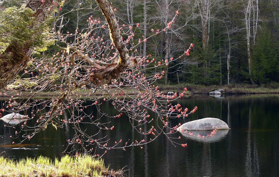
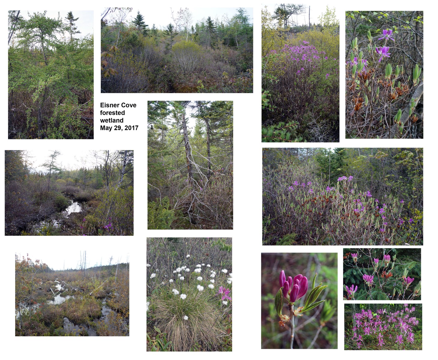
Rhodora coming into full bloom in Eisner’s Cove Wetland on May 29, 2017
Click on images for larger versions
Further Updates on this site/situation will be posted on Eisner’s Cove Wetland (new page on this website)
UPDATE, 2:46 p.m. Jan 11, 2022. The Motion received unanimous approval: “1.Initiate a process to amend the Regional Centre Secondary Planning Strategy and Land Use-By-law to develop site-specific Comprehensive Development District (CDD) policies and an associated development agreement to enable development on the Southdale Future Growth Node site that considers the review items identified in the Discussion Section of the staff report dated December 6, 2021; and 2. Follow the public participation program as set out in Attachment A of the staff report dated December 6, 2021” I guess the train had left the station when I wrote this piece. ‘Echoes of the Whopper Dropper.
————-
A critical decision related to the Eisner’s Cove Wetland could be made at Halifax Regional Council on Jan 11, 2022 re: Item 15.1.3
Is land in HRM now so intensely developed that we have to move into some of the most ecologically precious places, the linked climate and biodiversity crises and need for green space in settled areas notwithstanding?
Post by David Patriquin, member NSWFS
“Eisner’s Cove Wetland” is a near pristine, approx. 15 ha forested wetland located within a densely settled area of Dartmouth. NSWFS has organized several visits to the area in the last 5 years or so.
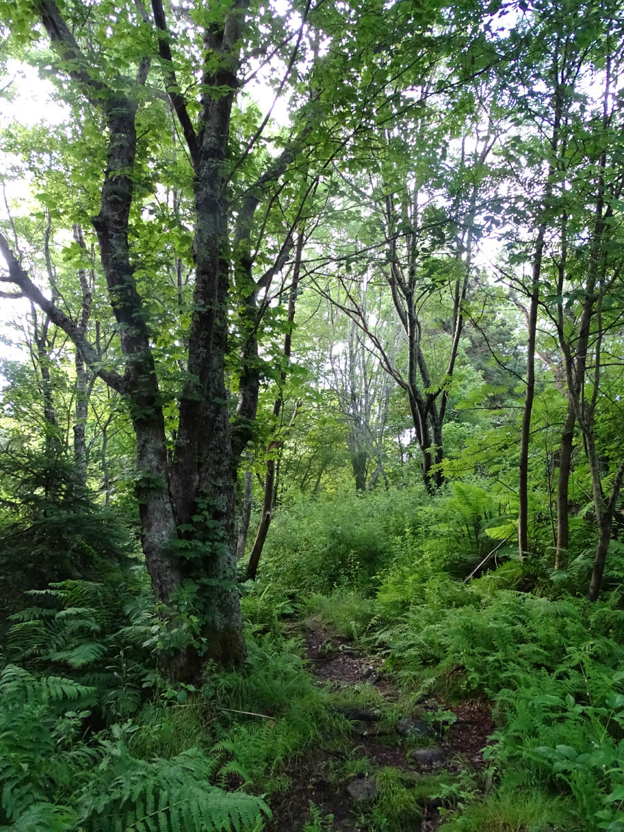
The wetland corridor downstream was filled in years ago, but somehow this Eisner’s Cove Wetland* was spared. Mixed Wabanaki-Acadian forest occurs on the slopes leading into the wetland.
*It’s not clear why it is known as “Eisner’s Cove Wetland” as it currently drains to the northwest and ultimately into MicMac Lake, not southeast towards Eisner’s Cove, although perhaps it did before the Circumferential Highway was built.
A large portion of the wetland and the adjacent forested land was owned by INNOVACORP when NSWFS members visited it in years past; INNOVACORP put it up for sale in early 2018.
INNOVACORP OFFERS MASSIVE DARTMOUTH ACREAGE. Devin Stevens. Government venture capital agency is inviting property developers to submit potential uses for more than 100 acres of land just inside Dartmouth’s Circumferential Highway, and the lease could be for the next 100 years. – from an ad in allnovescotia.com Mar 5, 2018
That land was owned by the Province before that, presumably it was turned over gratis to InnovaCorp, “Nova Scotia’s early stage venture capital organization”, when this quasi-government entity was formed.
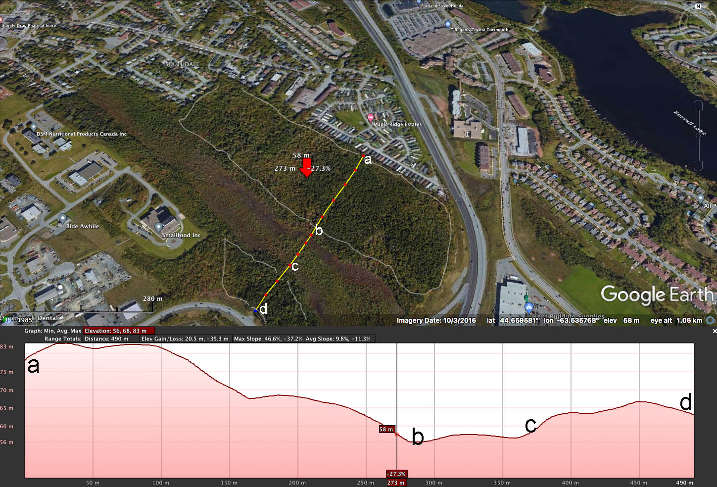
Google Earth image of Eisner’s Wetland & Environs, with elevation profile. Approximate areas proposed for development (based on diagrams in HRM document) are enclosed (NE side of wetland) or partially enclosed (southwest side) by white path. Panel at bottom is an elevation profile.
Flash forward, and apparently the land was purchased by A.J. Legrow Holdings Limited; now, according to CBC, “Zzap Consulting and Clayton Developments have submitted a plan on behalf of the landowner…[which involves placement of] 700 units of single-family homes, townhouses and low-rise apartment buildings, as well as a number of fourplex buildings with over and under flats that could be condominiums or rental apartments” on the property. (Halifax council considers proposal for 700-unit ‘attainable housing’ development – Pam Berman for CBC Jan 10, 2020)
CBC notes that “Halifax regional council will consider starting a development agreement process on Tuesday Jan 11, 2022 for what developers are calling “attainable housing” on 45 hectares of land in Dartmouth.”

Conceptual Plan (from HRM Document)
It’s all moving very quickly – the area has recently been identified as a “future growth node”. From HRM Case 23820: Southdale Future Growth Node Master Planning Initiation (Dec 6, 2021)
BACKGROUND On August 17, 2021, Regional Council directed staff to prepare a report to initiate a process to amend the Regional Centre Secondary Municipal Planning Strategy (RCSMPS) to develop a master neighbourhood plan for the Southdale Future Growth Node (FGN). This process will include Council’s consideration of site specific development agreement criteria through an amendment to the RCSMPS and the Regional Centre Land Use By-law (RCLUB), as well as a development agreement prepared as part of a parallel process.
The FGN designation is intended to support a comprehensive planning process needed to effectively guide the development of mixed-use communities with supporting public infrastructure. The following sections provide information on the site location and context and key enabling policies.
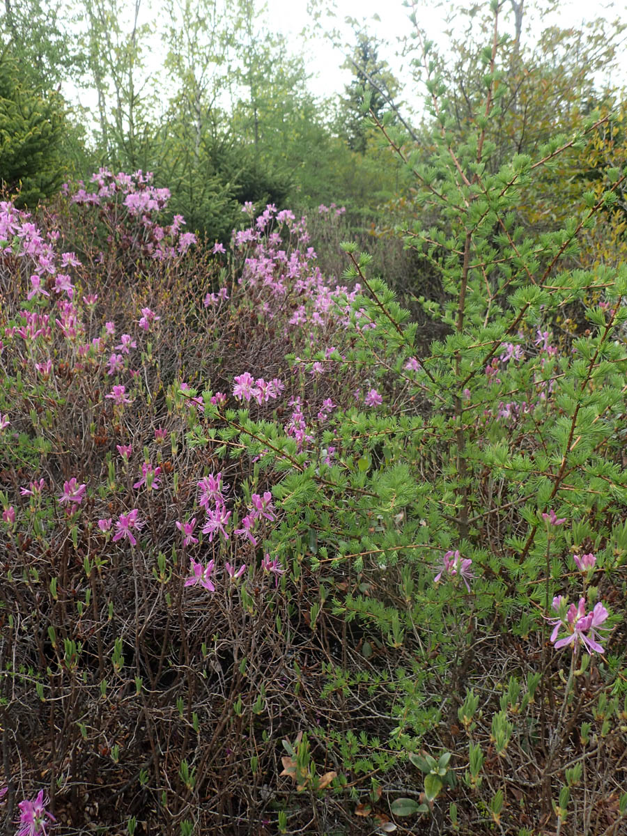
Wabanaki-Acadian forest on the NE slope June 25, 2017
Southdale Future Growth Node Context The Southdale Future Growth Node is located at the south-eastern edge of the Regional Centre, in Dartmouth, immediately adjacent to Highway 111 (“Circumferential Highway”) as illustrated on Map 1. The FGN is composed of four separate lots. Three of the four lots are held by one landowner and are undeveloped, including a significant wetland. The fourth lot is under separate ownership and is occupied by an office building, located on Research Drive.
The wetland is seen by the developers as a highly desirable “amenity”.
The site would also include six hectares of parkland, including a central park, a playground and trails around a wetland.
“Let’s create a feature out of this wetland,” said Neatt [Clayton’s vice-president of planning and development]. “It’s an incredible environment that people should be able to walk around. It should be and will be an amenity.”
Guessing from the map shown in the Conceptual Plan (see figure above), the riparian buffer between the development and the wetland as currently envisaged would be only circa 20 m wide (the minimum required by default; more could be specified). The land proposed for development lies on land sloping into the wetland on both sides.
Here’s what the wetland looked like on May 17, 2017:
There’s a lot of carbon sequestered and a lot of biodiversity in this wetland, also in the adjacent forested land. The area has informally maintained trails and is a treasured natural area get-away to many nearby, and even to many further away.

Eisner’s Cove Wetland & Environs Project on iNaturalist illustrates interest in the natural history of this area. As of Jan 11, 2022 10 observers have reported 246 observations/118 species!
This type of wetland requires acidic, low pH, low calcium conditions and low levels of nutrients such as nitrogen and phosphorus. It would be very difficult to avoid significant input of nutrients and road salt from a residential landscape as currently envisaged. A wider buffer zone might remove most nutrients (including calcium from liming, which will reduce acidity/increase pH), but would not absorb the salt.
I made some 0n-site measurements on flowing water in the wetland on June 25, 2017 using portable instruments:
temperature: 18.7
ph: 5.98
Electrical Conductivity: 182 uS/cm
The pH value was just above the upper limit (5.8) cited for Rhodora canadense seen in the photos above. pH of aquatic systems generally increases with increasing urbanization. Electrical Conductivity, a measure of salt content, was well above values for pristine waters in this area (circa 30-50 uS/cm). The CCME guideline for chloride ion for the protection of aquatic life is 120 mg/L for long term exposure, and 640 mg/l for short term exposure, corresponding approximately to EC values of 470 and 2410 uS/cm respectively, using the conversion formula given in AECOM (2020). It’s pretty likely the electrical conductivity would rise well above 470 uS/cm, if not the higher value, once the landscape begins to be developed.
While thin on detail, the wetland is cited as the major environmental concern in relation to the proposed development:
There is a large wetland on the subject lands. Policy F-3 requires that a land suitability assessment be undertaken to identify sensitive ecological elements, including wetlands. Wetland protection is a shared responsibility between the Province and the Municipality. Wetland alteration is the jurisdiction of the Province and the municipality regulates development adjacent to watercourses and wetlands. The Regional Plan requires minimum setbacks from wetlands and watercourses. The master neighbourhood planning process will consider additional protections for the on-site wetland.
| *Note Added Jan 13, 2022: It is also a watercourse – note reference above to flowing water above. As such additional protection not afforded to wetlands under HRM by-laws applies. See A Citizen’s Guide to Wetland Conservation in the Halifax Regional Municipality |
The decision about whether to go ahead with this project will apparently be made tomorrow (Tuesday, January 11, 2022), with two alternatives;
ALTERNATIVES
1. Regional Council may choose to initiate the consideration of potential policies that would differ from those outlined in this report. This may require a supplementary staff report.
2. Regional Council may choose not to initiate master neighbourhood planning to enable the comprehensive development of the Southdale Future Growth Node. A decision of Council not to initiate a process to consider amending the Regional Centre Secondary Municipal Planning Strategy is not appealable to the N.S. Utility and Review Board, as per Section 262 of the HRM Charter.
Is land in HRM now so intensely developed that we have to move into some of the most ecologically precious places, the linked climate and biodiversity crises and the need for greenspace notwithstanding? I think not.
Unfortunately, the HRM document being considered on Tuesday contains very little info. on the ecological values and sensitivity of the site. I hope the material on this page helps.
Related Docs & Websites
A Citizen’s Guide to Wetland Conservation in the Halifax Regional Municipality
“Prepared by East Coast Environmental Law In partnership with the Ecology Action Centre…The guide includes information about the Nova Scotia Environment Act, Environmental Impact Assessment Regulation, Nova Scotia Wetland Conservation Policy and HRM land-use by-laws and polices that impact wetland conservation”
Friends of Eisner Cove Wetland
Public Facebook Group
Paving paradise in Dartmouth
Robert Devet in the NS Advocate, Jan 19, 2016 “The Eisner Cove wetland, a 180 hectare piece of pristine wilderness, stretches from Shearwater all the way into the Penhorn/Woodlawn community in urban Dartmouth. Residents of that neighborhood dearly love the presence of a bit of wildness in their backyard. But now they worry that new development is signalling a change for the worse…In 2008 Zebedee chaired a community exercise to articulate what the neighborhood should look like in the future. The resulting document leaves no doubt as to what residents want to happen with the wetlands. “The Vision area includes two significant wetlands: Eisner Cove wetland (which is bisected by Highway 111), and another on the north side of Russell Lake. Home to a number of white tailed deer, fox, sharp-shinned hawks and other wildlife, the wetlands, although already impacted by surrounding development, are seen as valuable ecological assets to the community that should be protected,” the report states. [Link to “document” doesn’t work; it can be found here]
Feedback: Eisner’s Cove Wetlands
Claudia Chender, MLA Dartmouth South, Jan 24, 2020
I read with interest the article about the recent purchase of a large piece of land in Woodside from Innovacorp, a Provincial Crown Corporation. The CEO describes the land as not being usable “because there’s a big swamp in the middle of it”.
That “swamp” is the Eisner’s Cove wetlands, an ecologically sensitive area. The Friends of the Eisner’s Cove wetlands have been working for years to raise awareness about the area and its wildlife. They have also been organizing to prevent development since the time that Innovacorp first announced that they were planning their now abandoned expansion onto that site. Neither they nor the bordering Southdale community were consulted about the recent sale.
The Provincial government has declared a climate emergency. That doesn’t square with the sale of a parcel of government-owned wetland to a “shrewd real estate investor”. Set against the current controversy around the delisting of another sensitive area—Owl’s Head—to facilitate sale to a developer it establishes a concerning pattern. If this government took climate change seriously, they would have engaged the community on the idea of keeping the land and making it a proper and protected park, while potentially carving off other parts of the parcel for sale.
More Background:
Bill Zebedee posted this on the Friends of Eisner Cove Wetland on June 9, 2021:
Good day all. Council Austin posted this on his website (maps attached)
Southdale Future Growth Node
Probably the most significant item in District 5 in Package B is the Southdale Future Growth Node. The Southdale Growth Node covers the vacant land between the North Woodside Industrial Park and the residential development off Lynn Drive and Gaston Road. A large portion of property is a wetland (Eisener’s Cove) with the former Research Council lands next to Dartmouth South Academy being the only portion with any existing development. Up until recently, most of the property was owned by the Provincial government through the Crown corporation, Innova Corp. Being under government ownership meant it has attracted little to no interest from anyone for years.
When Package B began, staff identified the Southdale lands as a Future Growth Node. A Future Growth Node is a sort of placeholder that HRM has applied in the Centre Plan to lands that require more comprehensive planning to guide future development. Future Growth Nodes are typically large tracts of vacant or underused property that require that sort of big picture view. Examples from Package A include Dartmouth Cove, Shannon Park, Mic Mac Mall and Penhorn, all of which, except Mic Mac, have had detailed site specific visioning in the past. The Southdale designation was anticipatory as there was no actual request from anyone to do anything with the Southdale property, but HRM felt that if that should change, the Southdale lands are significant enough to require a dedicated planning process of their own.
What has changed recently is Innova Corp sold most of their lands and the property’s new owner is exploring options for development. The owner has partnered with Clayton and are looking at a residential development that would possibly feature low cost housing (Clayton is calling it obtainable) while preserving the wetland as a park. As a result of this interest, I moved a motion recommending that, upon completion of the Centre Plan, that HRM initiate a comprehensive planning process for the Southland Future Growth Node. There are potential opportunities here for the community. There is the potential to secure the wetland area as a park with formal walking trails and to fix the lack of a connection from Lynn Drive/Gaston to Mount Hope. There are transportation access challenges though to consider and details to work out as well as to exactly what lands could be developed, and at what scale. Sorting out where the boundary will be for industrial uses in the North Woodside Industrial Park and new residential development will also be important. I expect that we will be talking more about the Southdale Future Growth Node in 2022, maybe even late 2021.
————
POSTSCRIPT
For the Record. I made this post in the evening of Jan 10/early am of Jan1, 2022, after seeing a CBC News story about the impending vote by Halifax Regional Council posted in the early evening of Jan 10, 2022 – the first I had heard about it. I sent messages to members of the NS Wild Flora Society about the issue & I sent an email to my Councillor, considered a ‘progressive”, in the early am on Jan 11, 2022 with the subject line “Hope you can flag this one today”, and simply giving the link to this post in the e-mail.” I was shocked later that day when the Mayor and every Councillor, including mine voted to go ahead with the project. Here is the comment I got from my Councillor on Jan 12, 2022: “Hi David, going back the pre-centre plan MPS this land outside of the main wetland has always been up for development. It’s one thing to defend crown land or development reserves that have existed for 50-60-70 years, and it is another to expropriate land with rights already on it for at least 50 years. This land was designated for growth when I was still in elementary school.I am in support of this moving forward with the wetland protected.Sorry, I know it’s not what you wanted to hear.” MY REPLY: “A lot of things were scheduled for growth when you were in elementary school. Did you also learn about the climate and biodiversity crisis then? Biodiversity losses have happened mainly though incremental encroachment. When do we stop? Much or most of the land belonged to the province as I understand it (and was given to Innovacorp), so was Crown at one time. It will make a joke of riparian protection in HRM if it goes ahead as shown on the conceptual plan with the steep slopes on either side. If I live long enough, I will at least document the deterioration of the wetland. Anyway, thanks for being frank.” My Councillor replied on Jan 13, 2022: “Ha totally fair.”
Addendum:
From: Susan Van Iderstine
Date: January 13, 2022 at 11:17:15 AM AST
To: Mayor Savage, Councillor Austin and Minister Halman
Subject: Eisner Cove Wetland Preservation and the Southdale Future Growth Node
Hello Mayor Savage, Councillor Austin and Minister Halman,
I am writing to bring to your attention concerns regarding the proposed high-density mixed-residential development on the site of the Eisner Cove Wetland in Dartmouth. This development is in the planning stages, and the location is known as the Southdale Future Growth Node. The master planning initiation was approved by HRM city council on January 12, 2022.
The Eisner Cove Wetland is a diverse fen that has been whittled away through the years by city expansion. A small amount of wetland remains, protected and fed by a narrow belt of woodland. It is home to wildlife and to fragile plants.
This area may look like unused space to developers and to city council, but it is a rare gem. There is a walking trail through the woods that has been used by the public for years upon years. To walk there is to leave the city behind, city noise replaced by the quiet of old woods and the call of birds. In spring the ferns unfurl, the Lady’s Slippers, trilliums, dog-tooth violets and rhodora show their quiet beauty. If you are quiet and careful you may see deer, foxes, rabbits or porcupines going about their day.
Places like this are not vacant or underutilized. They are precious assets to be treasured and preserved. Houses can be built on any empty space. We have lots of empty space in and around Dartmouth. The plan for the Southdale development could be adapted to, for example, the unused Shannon Park site or a vacant business area. But a wetland cannot be moved to a more convenient location, and once it is gone it is gone for good. The wetland itself is fragile, requiring very specific conditions that are created by the surrounding woods. Without the woods the wetland dies.
I know we need housing. I applaud the developer’s stated intention to preserve the wetland as a feature of the development. I worry that it is not possible to achieve the environmental preservation outcome, and that this objective will be lost in the excitement generated by money and housing. I worry that this project has been, or will be, greenwashed.
I would like to better understand a few things:
Why is this wetland area designated for development, rather than for protection? Can this be changed?
What are the processes that will examine the viability of preserving the Eisner Cove Wetland? Which groups and experts will be consulted? How and when will this information be made public?
What is the weight that will be placed on environmental protection versus prioritizing commercial goals?
What public consultation activities are planned, and when will they happen? (I read the proposal, very little detail on this aspect.)
What alternative sites can be considered for this housing development?
As evidenced by the recent public outcry about protecting Owl’s Head, people in this province care about preserving our natural resources. A development plan that destroys an irreplaceable natural asset is controversial. A good idea, in the wrong place, is a bad idea.
I look forward to your reply, and to hearing more about the planning process.
Regards,
Susan Van Iderstine
Dartmouth, Nova Scotia
